Straight of Hormuz
How can space-based radio frequency detection help monitor a conflict? The Strait of Hormuz Under Pressure
Markets
Governments, Offshore facilities, Trade Intelligence
Location
Straight of Hormuz - Persian Gulf
Date
Oct 20, 2026
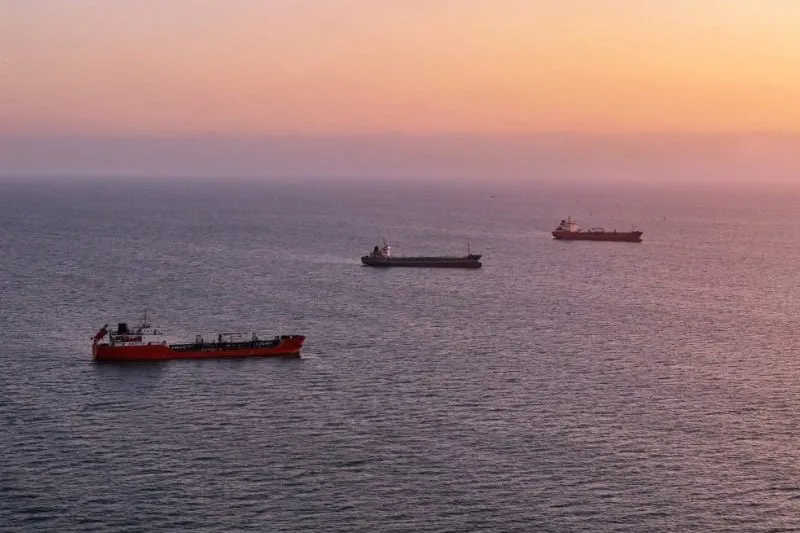
What Unseenlabs Reveals About Maritime Activity in the Strait of Hormuz.
In the Strait of Hormuz, fewer ships on an AIS map do not necessarily mean fewer ships at sea. Since tensions escalated in late February 2026, attacks, passage restrictions, and route changes have disrupted maritime traffic. Some vessels wait offshore, while others transit without broadcasting AIS, leaving gaps in maritime surveillance.
During its campaign, Unseenlabs detected a sanctions-listed vessel linked to Russia’s shadow fleet. This raises a key question: how can maritime activity be monitored during a conflict when AIS positions are missing?
Through three to four space-based radio frequency (RF) collections per day, Unseenlabs compared activity before and during deteriorating navigation conditions. This use case examines vessels detected without matching AIS positions and shows how repeated observations can support monitoring near sensitive subsea cable corridors.
Connecting the Persian Gulf to the Gulf of Oman, the Strait of Hormuz carries roughly a quarter of global seaborne oil trade, alongside LNG and other essential goods. Its strategic geography has shaped shipping routes and regional tensions for decades. The 2026 escalation has made vessel movements harder to monitor, highlighting the value of space-based RF detection.
A strategic passage shaped by decades of tension
The Strait of Hormuz, between Iran and Oman’s Musandam Peninsula, connects the Persian Gulf to the Gulf of Oman, opening onto the Arabian Sea and Indian Ocean. As a gateway to international markets, it concentrates major shipping routes. Since 1968, an International Maritime Organization (IMO ) traffic separation scheme has organized vessels traveling in opposite directions, making route changes particularly consequential.
Its economic importance is global. In the first half of 2025, an average of 20.9 million barrels of oil crossed daily, representing approximately one quarter of global seaborne oil trade. The strait also carried more than one fifth of global LNG trade, mainly from Qatar, and around one third of seaborne fertilizer trade . Although Saudi Arabia and the UAE have alternative pipelines, their capacity cannot replace normal flows through Hormuz. Disruptions therefore affect energy markets, freight costs, and food supply chains.
Below the surface, five active submarine telecommunications cable segments connect Gulf countries to international networks, making Hormuz a critical regional connectivity corridor .
The strait has also been a longstanding geopolitical flashpoint. Iran and the UAE dispute sovereignty over Abu Musa and the Greater and Lesser Tunbs. During the 1980s “Tanker War,” attacks on commercial vessels and naval mines threatened shipping. In 2019, tanker attacks and Iran’s seizure of the British Stena Impero renewed security concerns. This history continues to influence navigation, maritime security, and insurance decisions.
The latest crisis began on February 28, 2026, with U.S. and Israeli strikes on Iran, followed by Iranian retaliation. As attacks disrupted commercial shipping, vessels delayed departures or waited offshore. According to UN Trade and Development, average daily transits through Hormuz fell from approximately 130 in February to just 6 in March. By mid-April, nearly 2,000 vessels and 20,000 seafarers remained trapped in the Persian Gulf, according to the IMO .
An April ceasefire brought limited relief, with traffic reaching only around 10% of previous levels by late April, according to Kpler. A U.S.-Iran agreement in mid-June temporarily increased crossings, but renewed attacks in July reduced average daily transits from approximately 45 to 13 during the periods monitored by Kpler. By late August, the IMO estimated that up to 400 ships still could not leave safely.
By September, Kpler estimated that crude exports from Gulf countries excluding Iran had recovered to earlier volumes, but 40% bypassed Hormuz. Some tankers crossed with AIS switched off or transferred cargo offshore. On September 21, preliminary tracking data recorded just two commodity vessels crossing, excluding possible AIS-dark transits.
These developments show how conflict reshapes maritime traffic, leaving gaps between declared vessel movements and actual activity. Understanding these gaps is essential for effective maritime surveillance in the Strait of Hormuz.
Rising tensions in Hormuz are degrading maritime monitoring reliability
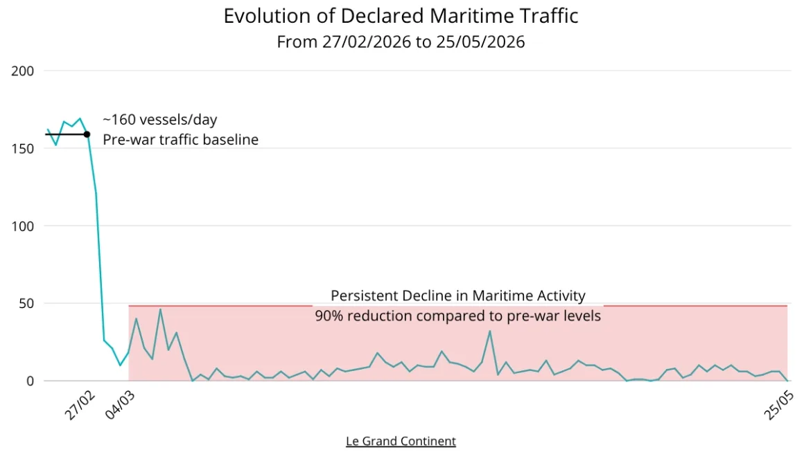
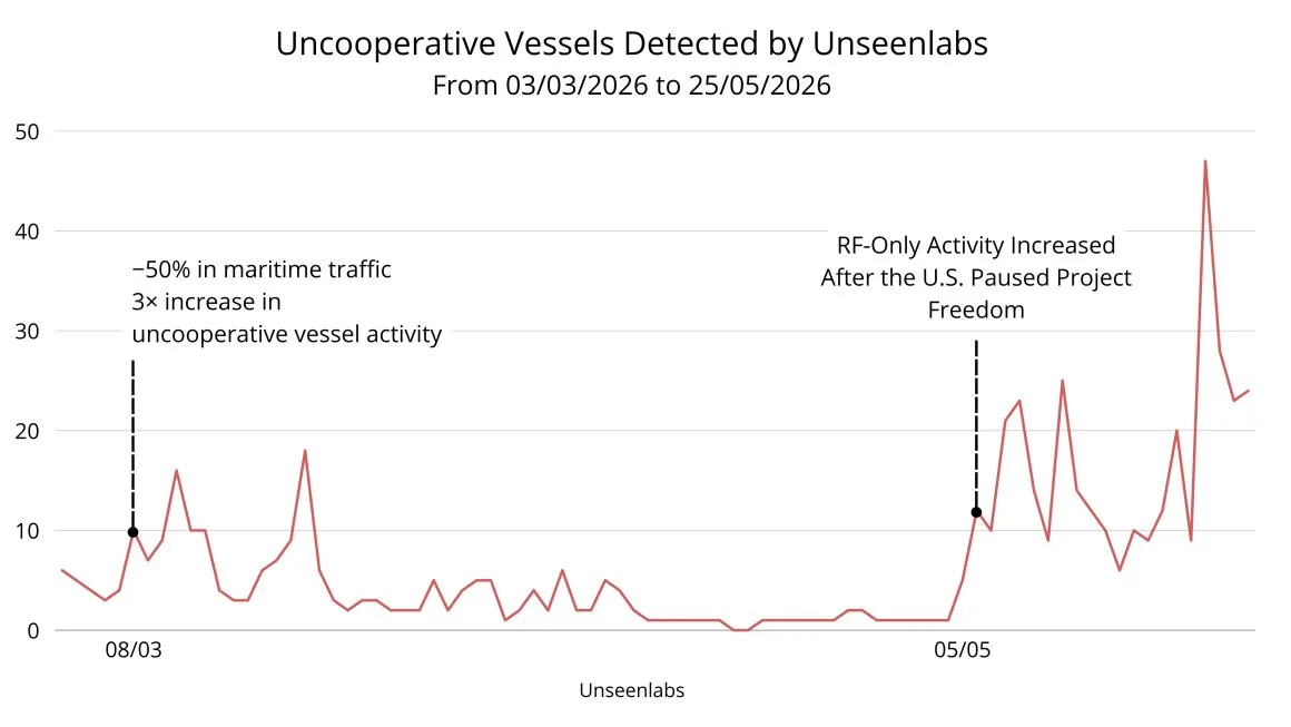
As declared traffic fell, Unseenlabs’ RF detections revealed activity that AIS alone could not show.
- February 27 | Baseline: Approximately 160 vessels per day appeared in the declared traffic data, immediately before the conflict began on February 28.
- March 7–8 | Diverging signals: The campaign figures show a 50% drop in declared maritime traffic alongside a threefold increase in uncooperative vessel activity.
- May 5 onward | RF-only activity rises: In the days following the U.S. decision to pause Project Freedom, Unseenlabs detected a further increase in activity without matching AIS positions. The timing does not, by itself, establish a cause.
Some vessels continued to operate beyond the view provided by AIS. Space-based RF detection helps reveal that activity, including near sensitive offshore infrastructure.
From usual observations to a surge in RF-only activity
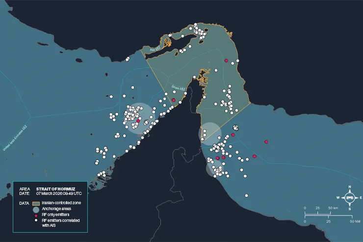
March 7, 2026 | A reference observation
By early March, the conflict had already disrupted passage through the Strait of Hormuz. Yet Unseenlabs’ collection at 09:49AM UTC on March 7 still resembled those of the preceding days. It recorded 555 correlations between RF detections and AIS positions. RF-only activity remained limited, accounting for approximately 1.8% of detections, with most unmatched emitters located outside the area marked as Iranian controlled. This snapshot provides a reference point for the campaign: most detected activity could still be connected to a declared vessel position.
That picture changed in the collections that followed. On March 7, Iran’s Revolutionary Guards claimed a drone strike on the tanker Prima. The next phase examines the surge in RF-only activity after the reported strike and what it reveals about the limits of AIS-based monitoring.
To the consequences of Iran’s strike
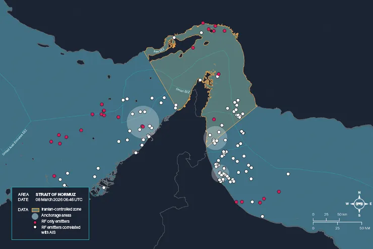
March 8, 2026 | RF-only activity surges
By the following morning, the pattern had changed. At 06:45AM UTC on March 8, Unseenlabs recorded 228 RF–AIS correlations, down from 555 in the March 7 collection. Meanwhile, the number of RF-only emitters had roughly tripled. They now represented approximately 12% of detections, with most located inside the area marked as Iranian controlled.
The two observations show how quickly maritime visibility can change: fewer RF detections matched declared AIS positions, even as more emitters remained detectable through RF alone. That gap becomes especially important when examining a vessel of interest.
The next observation shows how RF data helped confirm the position of a sanctions-listed tanker linked to Russia’s shadow fleet.
Confirmation of actual position of tanker listed on Russian dark fleet list
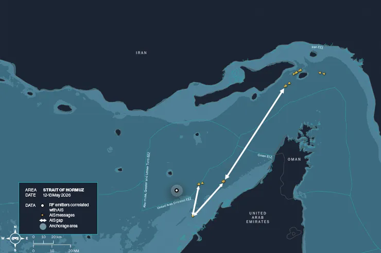
On May 12 and 13, a tanker listed as part of Russia’s shadow fleet traveled through the Strait of Hormuz. It had changed names and flags several times over its operating history. Its AIS positions traced a route from waters near Iran, around Oman’s Musandam Peninsula, and toward the UAE coast.
Three gaps interrupted that journey. While the tanker was anchored in the EEZ area marked around Abu Musa and the Greater and Lesser Tunbs, its AIS position disappeared for 4 hours and 35 minutes. A second gap lasted more than 13 hours. Later, near an anchorage off the UAE coast, its reported position was unavailable for another eight hours.
During that final gap, Unseenlabs detected an RF emission associated with the tanker near the anchorage, helping confirm its location. The successive observations show both where its AIS track broke and where RF data helped restore visibility.
RF monitoring over critical maritime assets
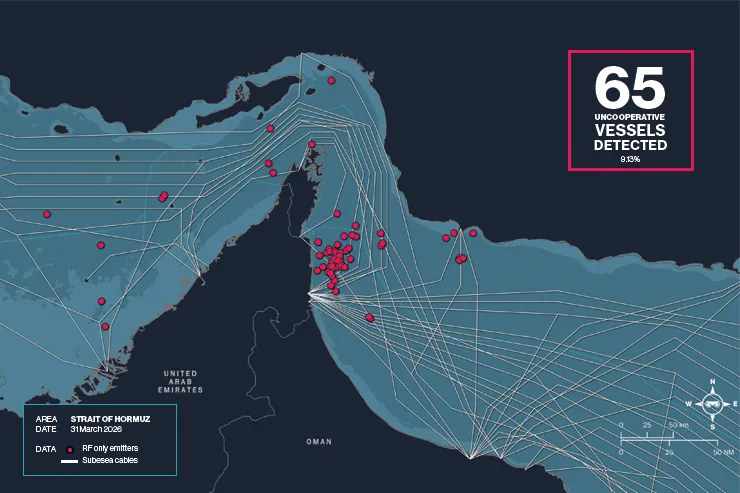
Beneath the Strait of Hormuz lies a network as important to the region as the shipping routes above it. Five active submarine telecommunications cable segments cross the strait, connecting Gulf countries to wider international networks. During a conflict, knowing which vessels are operating near these corridors becomes an important part of protecting regional connectivity. iscpc.org
On March 31, Unseenlabs detected 65 vessels with RF emissions but no matching AIS positions, representing 9.13% of the activity observed. Many were concentrated off the UAE coast, near mapped cable corridors. RF data established where these vessels were during the collection, even though their positions were absent from AIS.
If a cable incident were reported, these observations could help analysts identify activity requiring closer investigation. Proximity alone does not establish that a vessel interacted with or damaged a cable.
Turning RF Detection into Actionable Intelligence
Independent visibility when AIS is incomplete
Across the Strait of Hormuz, Unseenlabs conducted three to four RF collections per day. These successive observations located RF-emitting vessels, including those with no matching AIS position. As declared traffic fell, they provided another way to see how maritime activity was changing.
From detections to a clearer maritime picture
Comparing RF detections with AIS shows where vessel positions are declared and where activity is visible only through RF. Across multiple collections, analysts can examine changing transit patterns, ships waiting offshore, and activity near subsea cable corridors. These findings help maritime surveillance teams decide which areas and vessels merit closer investigation.
Gen 2 broadens the view
Introduced in July 2026, Gen 2 now extends Unseenlabs’ detection capabilities across the L (1–2 GHz), S (2–4 GHz), C (4–8 GHz), and X (8–12 GHz) bands. This broader frequency coverage opens access to more types of emitters, including maritime navigation and surveillance radars, satellite communications equipment, other radar and communications systems, and sources of GNSS interference. Unseenlabs
For maritime monitoring, these additional signals can help analysts examine activity when AIS positions are missing, assess operations near critical infrastructure, and investigate interference that may affect navigation. Gen 2 also extends RF monitoring to activity on land and in space, while Gen 1 continues to serve maritime missions. The initial Hormuz observations in this case study were collected before Gen 2’s first launch.
Conclusion
The Strait of Hormuz campaign shows how a conflict can transform both shipping and the ability to observe it. As security deteriorated, declared transits collapsed and vessels waited offshore. Yet Unseenlabs’ repeated RF collections continued to detect activity without matching AIS positions. The rise in RF-only detections in early March and again in May 2026, together with the AIS gaps observed for a tanker linked to Russia’s shadow fleet, shows why declared traffic cannot tell the whole story.
By comparing RF detections with AIS across successive collections, Maritime Domain Awareness analysts can locate emitting vessels during AIS gaps, examine changing routes and anchorage areas, and identify activity near subsea cable corridors for closer investigation. These observations establish where and when activity was detected. Further evidence is needed to assess a vessel’s intentions or any link to infrastructure damage.
Space-based RF detection helps monitor a conflict by providing independent observations when cooperative reporting becomes incomplete. Gen 2 now extends this approach to a wider range of signals across sea, land, and space. It opens the way to investigate new questions, including navigation interference, and to develop new use cases and markets.