UNCOVER THE INVISIBLE
While the rapidly expanding maritime sector is crucial to the global economy, reliable maritime traffic data remains insufficient.
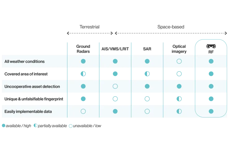
The Automatic Identification System (AIS) is the primary method for tracking ships at sea. However, AIS was not originally designed for vessel tracking and can be easily turned off or tampered with. These limitations create challenges for governments, NGOs, maritime agencies, and marine insurance companies that rely on accurate data for security, enforcement, and risk assessment.


SPACE-BASED Radio-frequency DETECTION
How It Works
Every vessel at sea is equipped with multiple electronic navigation and communication devices that continuously or intermittently emit electromagnetic signals.
Each LEO monosatellite in Unseenlabs' constellation features passive RF detection capabilities, intercepting radio frequency signals to detect and geolocate shipborne emitters across vast maritime areas.
UNVEIL THE UNSEEN
With RF intelligence, we see what others can't
Harnessing advanced algorithms and expertise, we transform raw signals into actionable intelligence. Our technology delivers accurate RF data on all vessels across vast sea areas, including dark ships that disable or manipulate AIS transponders to remain undetected.
KEY ADVANTAGES OF OUR RF TECHNOLOGY FROM SPACE
Unseenlabs produces and delivers exclusive RF intelligence that surpasses the limitations of declarative systems. Our technology seamlessly integrates with existing land, sea, air, and space detection systems, enhancing intelligence and surveillance capabilities.

Limitless
-
Unlimited Detection Range
far beyond shorelines, unlike coastal radars -
No Shipborne Equipment Required
independent of any onboard devices -
24/7, All-Weather Operation
effective day and night, even under cloudy or overcast skies -
Multiband RF Data Collection in a Single Pass
no need for multiple passes to cover different RF bands -
Global Operational Capability
not restricted by terrestrial or maritime borders -
Commercially Accessible Data
ITAR-free, available beyond public maritime security stakeholders
High performance
-
Highly Interpretable
fully compatible with any standard GIS system -
Lightweight Data
less than 1 MB per collection file -
Accuracy up to the Kilometer
enabling precise targeting for on-site inspections -
Low Latency
optimized for both strategic and tactical decision-making -
Extensive Coverage
an average of 300,000 km² per RF data collection -
Frequent Revisit Time
coverage of the same area multiple times a day

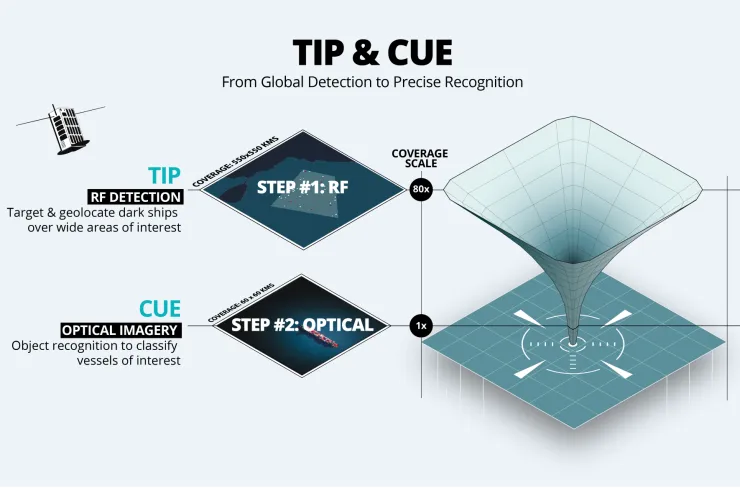
ENHANCING SURVEILLANCE WITH RF DATA
With its wide coverage in a single pass, Unseenlabs’ technology can be seamlessly integrated with Earth Observation technologies (optical imagery, SAR, and hyperspectral sensors), as well as land and maritime security systems (AIS, VMS, LRIT, etc.).
This "Tip and Cue" approach enables maritime stakeholders to achieve a new level of awareness, enhancing the monitoring of key areas, vessels, and offshore infrastructure at sea.


.
What is Geospatial Intelligence (GEOINT)?
Geospatial Intelligence (GEOINT) involves processing and analyzing geolocated data, software solutions, and human expertise to gain deeper insights into physical phenomena (such as geology, hydrology, oceanography, and meteorology) and to monitor human activities on Earth.
What do ELINT and SIGINT mean?
SIGINT (Signals Intelligence) refers to intelligence derived from electromagnetic signals, which includes ELINT (Electronic Intelligence) that focuses on signals emitted by radars, telemetry instruments, and other electronic systems, and COMINT (Communications Intelligence), which involves intercepting communications transmitted via radio or satellite waves.
SIGINT complements other intelligence disciplines, such as HUMINT (Human Intelligence), which is intelligence gathered from human sources, OSINT (Open-Source Intelligence), which is information collected from publicly available sources, and IMINT (Image Intelligence), which is intelligence derived from satellite or aerial imagery.
What is "Tip & Cue"?
Tip & Cue is a surveillance technique where a sensor scans a wide area to detect fixed or mobile objects of interest. Based on the initial findings, additional sensors are then tasked to focus on specific behaviors, areas, or objects, allowing for more detailed investigation and reducing uncertainty.